Thunderstorms around the country are expected to put a dramatic end to this record-breaking heatwave.
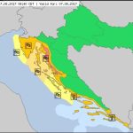
It seems that our heatwave Lucifer might finally be letting us cool down for a moment – unlike the past days when the map was constantly red, there are now some orange regions as well.
However, don’t get too happy too son – locally strong thunderstorms are possible in most of the country in the evening. In the greater part of the Adriatic variable winds, mainly SE and SW 4-12, and in the North Adriatic NE winds 6-16, in places of the Velebit Channel up to 22 knots, easing around midday and strengthening again toward the evening. Sea 1-2, in the North Adriatic 2-3. Visibility 10-20 km. Mostly clear, but cloud increase with a risk of isolated rain showers and thunder expected in the North Adriatic from midday and elsewhere later on, DHMZ reports.
In combination with high temperatures, this means extremely dangerous weather, so keep safe and try to avoid navigating in these conditions.
Knin, which keeps breaking records when it comes to temperatures regularly every summer, has had the longest consecutive period of temperatures over 40°C in history, so this past week was the hottest in its history. The hellish weather probably contributed to yesterday’s Day of Victory and Homeland Thanksgiving festivities being one of the least attended yet – there were around 8,000 people.
Other than that, it will be sunny, and very hot during the day, with showers and thunderstorms expected everywhere, the only exception being the Dalmatian coast.
Temperatures during the day in most countries will reach 34 to 40°C, 29 to 33 °C in the mountains.


