We’ve reported about the meeting of the Government cabinet, which was held in Split a couple of days ago.
A lot of large infrastructural projects were discussed and announced at that meeting; for instance, Minister Goran Marić spoke about how the former army barracks at Dračevac would finally be returned to the city of Split and put to commercial use, almost 9 years after Prime Minister Sanader signed the documents that were supposed to do just that: donate the property to the city, where the same technological park was planned. As I said, it was 9 years ago, so I don’t have a TCN link for you, but there are links in Croatian to prove it. Fast speed railway between the Split Airport and Split port, with the construction of the all-new Central railway station, worth around 1 billion kuna was supported, and 2 more billion kuna were promised for the construction of a multi-modal platform solution to the Split bypass, etc.
One other project was mentioned, which might make some eyebrows raise: digging of yet another tunnel in Dalmatia, connecting Drvenik, a small ferry port near Makarska with exit Ravča on the A1 highway. The tunnel would go through the Rilić mountain, which is a part of the Biokovo mountain range, around 50 kilometers south-east of the other tunnel through Biokovo, Sveti Ilija tunnel, which was open in 2013 and which was made toll-free for all passengers at the beginning of this year (while, at the same time, Učka tunnel has been open for traffic for over 35 years, and there’s still quite a steep toll to pass there).
Once it’s built, the tunnel would bring the ferry port of Drvenik much closer to the highway, which would present an interesting opportunity for some of the Dalmatian islands (there used to be a Drvenik-Korčula ferry line, which was discontinued in 2014), at the same time making the Vrgorac region (which is near Ravča highway exit) more accessible to car traffic from the coast. There is, of course, a highway going from Vrgorac to Ploče, 30ish kilometers, but apparently the region around Vrgorac needs another access point to the coastline.
The tunnel is just one part of the wholesome Project of the traffic connectivity of Hvar Island, and that project should connect Poljica near the centre of the island with Sućuraj, a ferry port on the eastern-most tip of the island by a modern, normal road, unlike today’s road which is stuff from the traffic nightmares. The project would include the complete reconstruction of Drvenik and Sućuraj ferry ports, would allow for better tourist and overall growth of the Eastern part of Hvar Island (which is, admittedly, almost completely empty and less popular with tourists). And in some of the documents explaining why this would be needed for the growth of Hvar Island it says that this project would help further development of the Jelsa municipality!

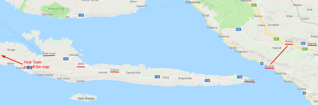
To make sense of that, please take a look at the map. I have underlined the important places in this story, you can see Vrgorac and Drvenik on the East (right-hand side of the map), hand-drawn line where the tunnel might go, Sućuraj on Hvar, the long and winding road to the Western, more developed side of the island which is supposed to be reconstructed, and Jelsa just 10 km from Stari Grad and under 30 from Hvar town – which are both frequently connected to Split and other Dalmatian islands by ferries, catamarans etc. during the tourist season!
So, while I don’t doubt that the project of the tunnel, the reconstruction of the two ferry ports and one horrible road are basically an excellent idea, I am not fully convinced of the return of investment for such a megalomaniacal and extremely expensive project. Of course, for now there are no official numbers of how much all of that would cost, but unofficial figures are around 130 million Euro, and even those who are proposing it are aware of that, if they are willing to say that Jelsa is one of the Eastern municipalities of Hvar!
CORRECTION: The original version of this article fails to acknowledge the fact that Jelsa Municipality is the largest one on the Hvar Island, that its boundary is far to the East from the Jelsa town, all the way to Bogomolje, and that it’s entirely possible that the Eastern part of the municipality would benefit greately from the tunnel, if not Jelsa town itself.
Subscribe to our newsletter
the fields marked with * are requiredRelated posts:
 Hvar Water Wars: Consumption is Way Above Average, There is no Sabotage!
Sućuraj Fails to Adopt Municipal Budget Due to Dispute with Norwegian Company
Ministers of Tourism, Finance on Hvar to Celebrate Suncani Hvar Record Results
Nikki Beach Hvar: In Sućuraj, Arguments About Who Can Sell Their Land to Investors
Hvar Water Wars: Consumption is Way Above Average, There is no Sabotage!
Sućuraj Fails to Adopt Municipal Budget Due to Dispute with Norwegian Company
Ministers of Tourism, Finance on Hvar to Celebrate Suncani Hvar Record Results
Nikki Beach Hvar: In Sućuraj, Arguments About Who Can Sell Their Land to Investors