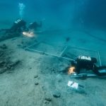
As Slobodna Dalmacija writes on the 14th of February, 2020, there are more than 200 underwater archaeological sites below the surface of the sparkling Adriatic in Split-Dalmatia County, ranging from isolated finds of small artefacts to preserved shipwrecks carrying amphorae and shipwrecks from World War II.
Archaeologists Sasa Denegri, Silva Kukoc and Tea Katunaric Kirjakov, an archaeologist and art historian at the Art Academy of the University of Split, have produced a cultural and tourist guide called “The Underwater Heritage of Split-Dalmatia County”.
The aim of this guide is to promote Central Dalmatia’s rich underwater archaeological sites in order to get a complete picture of the diversity and importance of the underwater world, and encourage the further development of archaeological and diving tourism in Split-Dalmatia County, according to Dalmacija.hr.
“Our underwater heritage stands out as an added value to Croatian tourism. Throughout the guide, almost all the localities in our county are listed along with all the directions, the depth they are located at is detailed, and what is permitted in these areas is also detailed. I believe that through the Split-Dalmatia County Tourist Board, all those tourists who want to see these cultural sites in an organised way will be acquainted with them. I’d also like to thank the authors of the guide, as well as the county services who have done something extremely valuable and of high quality,” said Prefect Blazenko Boban.
In addition to Split-Dalmatia County’s prefect, the guide was presented by the Head of the Department for Tourism and Maritime Affairs, Stipe Cogelj, and the Director of the Tourist Board of Split-Dalmatia County, Josko Stella.
The cultural and tourist guide to the underwater heritage of Split-Dalmatia County presents 28 underwater sites and three museum collections with underwater archaeological finds. The guide is designed in such a way that the waters of Split-Dalmatia County are divided into five geographical areas (the waters of Split and the Bay of Kastela, the waters of the island of Brac, the waters of the island of Hvar, the waters of the islands of Vis and Palagruza), and it covers the period from prehistory right up to the Second World War.
All localities are approximately indicated on maps, and different colours indicate different depths of sites.
A separate section also deals with the Battle of Vis as the most significant naval battle on the Adriatic sea and the three wrecks that participated in the battle as one of the most significant underwater finds in the Adriatic.
During the development of the guide, it was ensured that it represented different types of cultural domain from all historical periods, covering all of the waters of the county (ancient remains of architecture and shipwrecks, late medieval shipwrecks, and the remains of modern-day wrecks and planes from World War II). In addition to the historical and geographical information, each site has its own level of depth and accessibility for visitors.
The guide is available in Croatian and English.
Make sure to follow our dedicated travel page for more.


