Thought the roads were busy? The sea provides no respite!
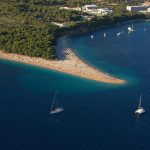
We don’t really need to tell you about how beautiful the Croatian coast is, nor do we have to tell you just how busy it gets during the summer months, with reports of records being broken seemingly continuous in the media, it should come as no surprise that it isn’t just the roads that are booming. The sea is too.

Ever heard of Vessel Finder? The service offers free AIS Ship Tracking with worldwide coverage in several languages and allows the user to track maritime traffic interactively and view its density in any part of the world.
With descriptions of harbours, port positions and detailed views provided for more than 4,000 ports all over the world on its maps, Vessel Finder offers additional information such as vessel movements, speeds, courses, building location, year of production and size.
The map cleary depicts the level of maritime traffic in the Adriatic sea during the peak season, mirroring any similar image taken of the current state of the Croatian highway system.