Here is the entire press release of the Croatian Geological Survey (HGI).
The active tectonics of the entire area of Croatia, including the wider epicentral area of Pokupsko-Petrinja-Sisak, is caused by the continuous movement of the Adriatic lithospheric microplate (Adria) to the north. Therefore, in the upper parts of the Earth’s crust, great strains occur at the contact of the Dinarides and the Pannonian Basin. When the strain reaches a critical level, individual faults from that system are (re)activated. There is a sudden movement of kilometers blocks of crust with dimensions of several hundred to thousands of cubic kilometers. As a result, a massive amount of energy is released, and earthquakes occur.
According to preliminary geological analyzes of Croatian Geological Survey’s scientists and experts, based on geological maps, numerous field data published in the media, field prospecting, available seismological, and preliminary satellite data, the earthquake that hit Petrinja and its surroundings on December 28, 2020, activated the fault system in the underground of the broader area of Sisak, Petrinja, and Glina. (photo below)
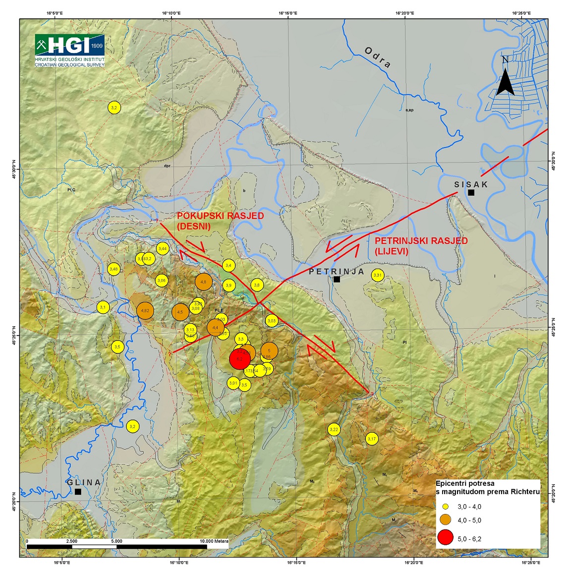
Geological map of the Petrinja and Sisak area with highlighted main faults from activated fault systems that caused earthquakes on 28 and 29 December 2020. / Croatian Geological Survey
It is evident that it is the intersection of longitudinal and transverse faults on the extension of the Dinarides. Both fault systems consist of multiple faults with horizontal wing movement (strike-slip). One is the lesser-known fault, which on this occasion is marked as the left Petrinja fault, and the other is the better-known right Pokupsko fault. Such a fault system is a textbook example of deformations that occur in rock due to compression stress along the north-south axis.
Both fault systems are shown on the Basic Geological Map of the Republic of Croatia 1: 100,000, page Sisak, prepared by the Institute of Geology HGI (Pikija, 1987), and on the overview geological map of the Republic of Croatia 1: 300,000 (HGI, 2009). All geological maps covering the territory of the Republic of Croatia are available on request on the Croatian Geological Survey’s website.
Due to a large amount of released energy during the movement of fault wings, ruptures in the rocks were manifested on the surface of the terrain, so in the wider epicentral area along fault lines, we find various surface manifestations of this movement and vibration of the terrain: open cracks and paraclasses, fluid spills, sand volcanoes due to liquefaction in the Kupa and Sava river basins, deformations of the surface of the terrain and infrastructural line facilities, and numerous other, hitherto unusual phenomena for our area, which can also cause various subsequent geohazard events. Part of the deformation of the terrain between Petrinja and Glina is probably due to the collapse of the underground corridors of the brown coal mines that operated in the first half of the 20th century and were not adequately rehabilitated (buried).
More data and details on the activated fault system will be available upon completing field research by the Croatian Geological Survey’s teams.
Dr. sc. Tvrtko Korbar, scientific advisor of the Croatian Geological Survey
For more on the Petrinja earthquake and to see how you can donate money, food, humanitarian, sanitary and material aid, follow our dedicated section.