If you were to take the Great Roman Subway this summer, where would you get off the train?
When you ask someone to cite a couple of things Croatia is known for, you’re sure to hear ‘historic sites’ somewhere in the top 5. Some of the most visited destinations in the country boast well-preserved architectural gems and artworks dating back to the classical age: Pula, for example, owes its fame to the stunning amphitheatre and the temple of Augustus. Actually, one doesn’t even need to look further from Split, a city that’s literally blooming inside the walls of Diocletian’s Palace.
It’s no surprise, then, seeing some of our classics featured on the incredible diagram of the Roman Empire – structured like a subway map! Designed by Sasha Trubetskoy, the diagram is based on the historical grid of Roman roads in 125 AD, tweaking the actual territory only to the extent required to keep the whole design as minimalist as possible. According to Trubetskoy, multiple routes kept their actual names, and he improvised others using city names from the Roman age.
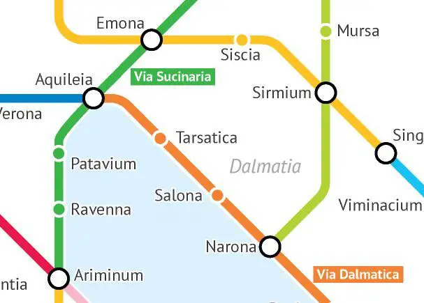
Three routes pass through Croatian territory. There’s the most obvious Via Dalmatica in bright orange, going south via three Adriatic stations: Tarsatica (after the Roman settlement in Rijeka), Salona (ancient city near Solin in Dalmatia) and Narona (settlement in the Neretva Valley). Why no Split? Even though the area was supposedly inhabited long before Diocletian’s age, the site became a focal point on the coast only after the famous emperor built his magnificent palace around 300 AD.
A bit further to the north, you’ll find Siscia as part of the yellow Via Gemina. Today known as Sisak, the area was home to the ancient settlement Segestica, conquered by Emperor Augustus in 35 BC and turned into a military camp.
Finally, there’s the bright green Via Aurelia, the only one carrying a real name dating back to the Roman times. The route passes through Mursa (Osijek) and turns down south to its final stop in Narona on the coast.
Some creative liberties and moving the borders are to be excused here, as the map is a remarkably elaborate and entertaining piece. Here’s a link to the HR version if you want to peruse the rest of the Empire subway system, and make sure to check other work made by the talented designer!
Source: Sasha Trubetskoy, Roman Roads