While we are still waiting for Croatia to be displayed on the Re-open.eu website, by counties, and not in two regions, the Croatian Tourism Association (HUT) has changed its epidemiological map of Croatia, which daily shows the situation in counties and larger islands – croatiacovid19.info, reports. HRTurizam.
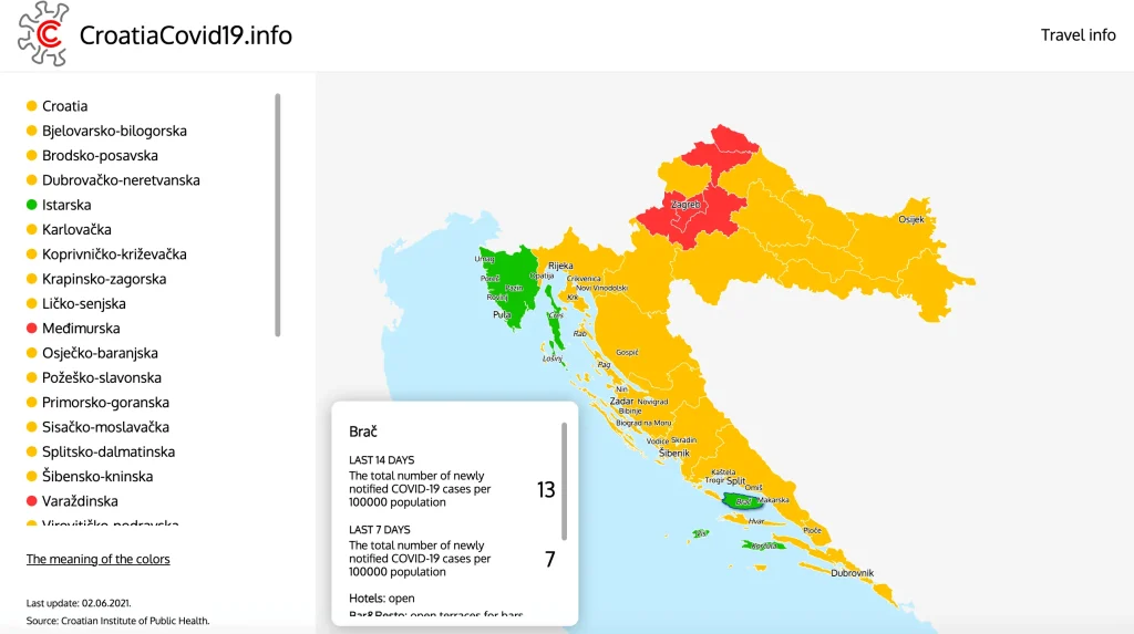
The map is updated with new data every day. It shows all the key standardized indicators of the epidemiological situation in the country – the daily number of new cases, the incidence per 100,000 inhabitants in the last 14 and the last 7 days, the number of active cases, and the share of positives in the last seven days. In addition, key measures related to restaurants, working hours, and other important measures for tourists are presented, both at the national level and at the level of individual counties. All these data are updated daily for each county, and the epidemiological situation is monitored separately on the larger islands.
Following the epidemiological situation, counties and islands are assigned colors defined by the criteria of the European Center for Disease Prevention – ECDC. According to these criteria, the “green” is currently Istria County and 5 Croatian islands – Brac, Cres, Korcula, Losinj, and Vis, which have less than 25 new cases per 100,000 inhabitants in the last 14 days.
“Regional presentation of the epidemiological situation in Croatia is crucial for the correct communication of the epidemiological situation in the tourist season towards our major markets. Germany has continuously supported the regional approach to the counties in Croatia since last season. Now it has been accepted by Austria, which is extremely important for this season’s success. We believe that this is the best way to motivate the local population to behave responsibly, especially in tourist counties where safety is a prerequisite for tourist traffic. I thank you for your support in preparing this map and providing all the necessary information to the National Civil Protection Headquarters, the Ministry of the Interior, the Croatian Institute of Public Health, and the Croatian Institute for Health Insurance,” said Veljko Ostojic, director of the Croatian Tourism Association.
The epidemiological map will be regularly communicated through all official channels of the Croatian Tourism Association and the channels of the largest tourist companies, members of HUT. Last season, the epidemiological map of HUT was reviewed by 750,000 visitors, of which 55 percent from Germany and then from Austria and Slovenia, and gave much crucial information that prompted them to travel to Croatia.
You can see more HERE.
For all, you need to know about coronavirus specific to Croatia, including travel, border, and quarantine rules, as well as the locations of vaccination points and testing centres across the country, make sure to bookmark our dedicated COVID-19 section and select your preferred language.