May the 27th, 2019 – taking a closer look at beautiful Vis and its UNESCO heritage.
On the 17th of April, 2019, the UNESCO Executive Board approved the designation of eight new Global Geoparks which demonstrate the diversity of the planet’s geology. Croatia’s Vis archipelago got this recognition. This article will take a closer look into some natural heritage from the stunning Vis archipelago.

The Vis archipelago covers the island Vis and the surrounding islands and islets Biševo, Sveti Andrija, Brusnik, Jabuka, and Palagruža. The archipelago is the area that has the oldest and youngest geological formations.
Some parts of the archipelago are made from volcanic rocks while most of the Adriatic islands are made from sedimentary rocks. Sailors and fishermen were always aware of this specific geological area. They knew when they would sail close to volcanic islets of Jabuka and Brusnik as their compass would divert from the north, potentially putting them in danger. Vis island has parts where the foundation is volcanic rock, which created several water springs. These springs created fertile conditions, so it’s no wonder the ancient Greeks chose Vis about 2,400 years ago as the place to found their first colony on the Adriatic.

The Vis archipelago is located off the coast of Croatia, and there some of the oldest rocks in the Adriatic sea, formed 220 million years ago, can be found. Sedimentary rocks are the base for most of the Vis archipelago. The origin of these rocks comes from the lithification process of sand, mud, and sea organisms.
The north-eastern region of the archipelago includes large sand deposits formed in the Ice Age which created unique forms and caves. Before the sudden rise of the sea level 12000 years ago, these islands were much larger and extended more than twenty miles. In this extended area called Mala Palagruža, an archaeologist discovered flint quarries that served for the production of early tolls believed to have been made by the islands’ first inhabitants.
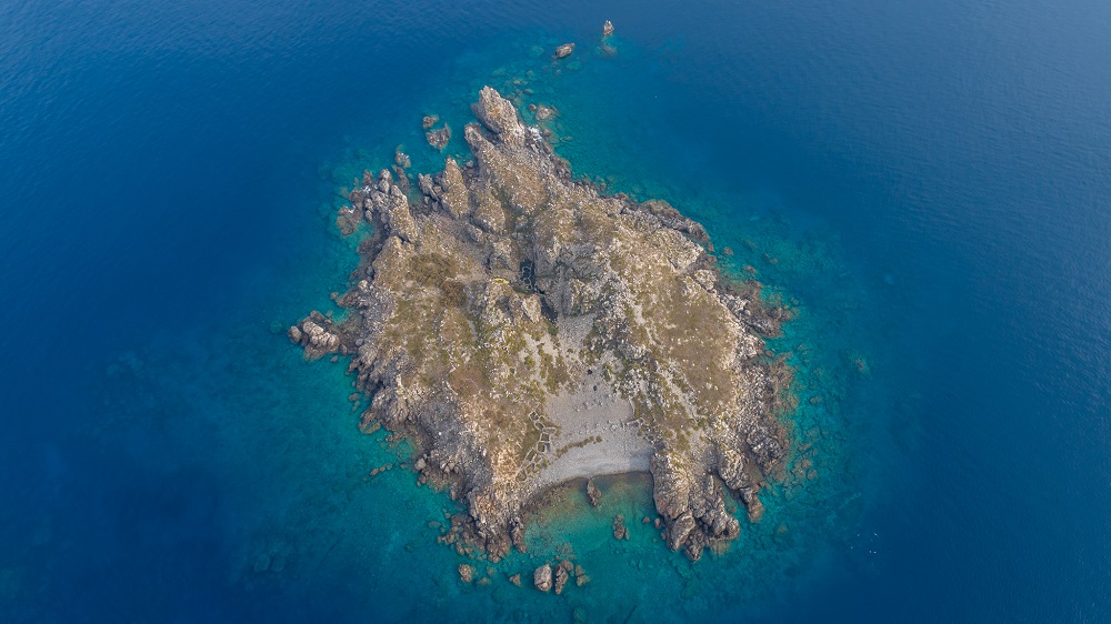
The Vis archipelago is formed around Vis island and includes a number of nearby uninhabited islets: Ravnik, Budihovac, Veli Paržanj, Mali Paržanj, Greben, Host, Veli Barjak and Mali Barjak and the open sea islands among which the most remote are the island of Palagruža, inhabited only by lighthouse keepers, and the magmatic island of Jabuka, some 30 nautical miles west of Vis. The surface of this maritime area covers almost 6000km2 and also includes Sveti Andrija, Brusnik and the island of Biševo which, is the only inhabited island.
In this area, the largest number of ”monuments of nature” in Europe can be found – Blue Cave, Monk Seal Cave, the volcanic islets of Jabuka and Brusnik, Stiniva Cove, and the Green Cave on the islet of Ravnik.
The Vis archipelago is a small area, but it boasts a wide range of significant landscapes and protected monuments of nature, some of which attract a lot of visitors.
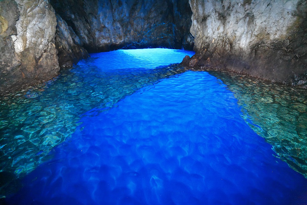
The Blue Cave
In 1884, the Viennese painter baron Ugen Ransonnet introduced the Blue Cave on the island of Biševo to the world. His discovery marked the beginning of tourism in Dalmatia, and the Blue Cave has since become a must-see tourist spot in the Adriatic. The Blue Cave has been a protected geomorphological monument of nature since 1951. Visitors can go to the cave from Biševo Mezoporat. There are people all over the world visiting this unique cave every summer.
The Monk Seal Cave
The Monk Seal Cave is the longest sea cave in the Adriatic – 160 metres. It is a protected geomorphological monument of nature from 1967. The name comes from the Mediterranean monk seal which once lived here.
Jabuka islet
Rising above the sea like a black pyramid, the island is 30 nautical miles from Komiža, is 97 metres high, and is a protected geomorphological monument of nature from 1958. The island is composed of deep crust magmatic rocks, the magnetite of which interferes with seafarers’ compasses making navigation in conditions of poor visibility extremely difficult when near it. The underwater area is rich in fish and crabs, which is why fishermen from Komiža go to Jabuka in winter and risk their lives going to the island, which has no docks.
Jabuka doesn’t have a natural bay and doesn’t provide shelter from the wind. Anchoring a boat is a difficult task due to the deep sea around the island, and its smooth rocks polished by the sea make it impossible to tie the ship around them. There are as many as twenty toponyms here, and these are the only human traces on this further insular frontier of the eastern Adriatic. The island is made from volcanic diabase rocks and is home to the endemic black karst lizard and two endemic plants.

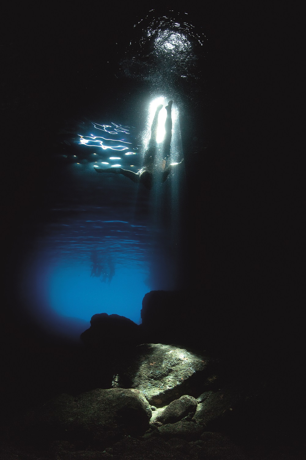
The Green Cave on the islet of Ravnik
This cave is a protected geomorphological monument of nature from 1967, and the islet itself is a significant landscape. The Green Cave has two large openings to it and it doesn’t give the same type of blue light effect as the Blue Cave, but it’s entirely unique because it has a small opening in the middle from where sunlight breaks into the cave and lights up the sea bottom like a spotlight in the darkness. The blackness of this cave enhances the intensity of this miraculous spotlight.
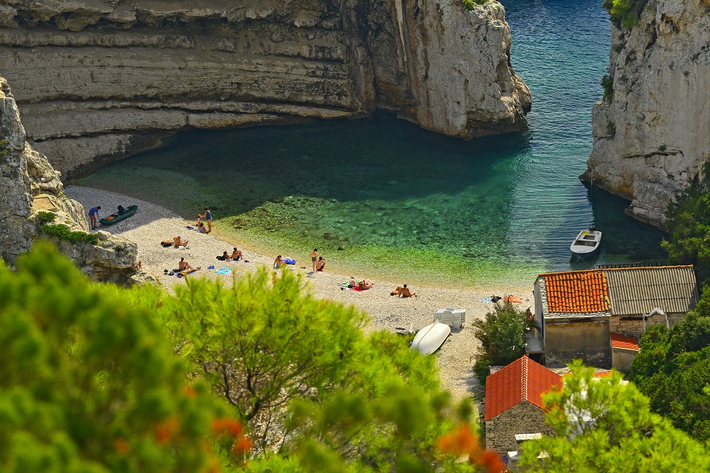
Stiniva bay
Stiniva bay has been classed as a significant landscape since 1967. This narrow and long bay ends with a stone ”gate” leading into a small cove with a pebble beach surrounded by layered rock walls. Once, Stiniva was a karst cave and it probably collapsed several thousand years ago. In 2016, Stiniva was named the most beautiful beach in Europe.
Ravnik islet
Ravnik islet is a significant landscape of nature and is located off the eastern coast of Vis, boasting its green cave.
Brusnik
Brusnik is the protected geomorphological monument of nature and is located thirteen nautical miles from Komiža. Brusnik and Jabuka are the only islands in the Adriatic formed from igneous rocks. It is 23 meters high, and both Brusnik and Jabuka are made of subvolcanic diabase formed by the crystallisation of magma on its way from the deep magmatic core up to the surface. Brusnik island is far more complex than Jabuka, however. Brusnik has paleo beach pebble conglomerates which can be found on the top of the island.
In the middle of the island, there is a ravine with a depression filled with seawater used by fishermen from Komiža, in which they made larger pools to keep their captured lobsters. There are also the remains of fishermens’ cottages built from large rocks. These small homes were in use for salting fish in barrels and to keep the fishermen safe from the wind and sun. Brusnik has been a protected area since 1951 and it boasts a special structure – as most of the islands have a limestone base.
There are several geo-trails in Vis archipelago, here are a few handy links to them:
Geo trail Komiža: https://geopark-vis.com/en/geology/geo-trails
Geo trail Biševo: https://geopark-vis.com/en/geo-trail-bisevo
Geo trail Vis Rukavac: https://geopark-vis.com/en/geostaza-vis-rukavac
A list of geological locations can be found here: https://geopark-vis.com/en/geostaza-vis-rukavac
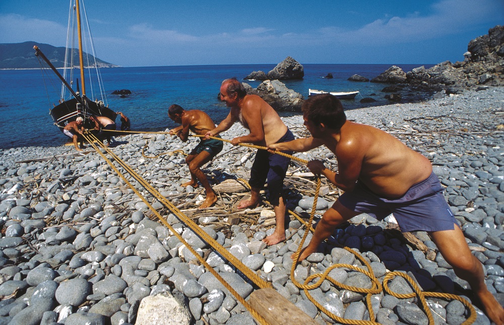
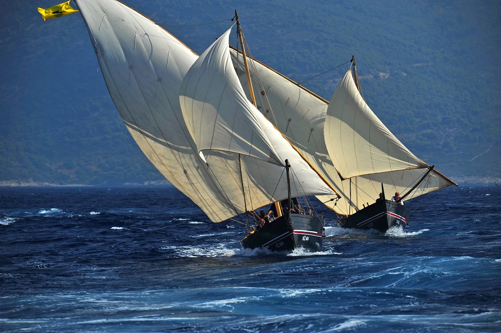
With this geological area, there are naturally a lot of local traditions and pieces of heritage worth knowing about. Some of the most valuable are Gajeta Falkuša, Suhozid – dry stone walling (another piece of Croatia’s intangible UNESCO heritage), The local Vis dialect, Gajeta Falkuša, which is a traditional historical fishing boat. Fishing has been the traditional main occupation of local men from Komiža for centuries. Komiža fishermen are well known as the first to catch fish on the open sea and to face a lot of dangers due to poor weather conditions and pirate attacks.
Local inhabitants lived off the sea and were facing different threats. To fight the open sea and the risks that faced them, fishermen needed to have small and quick boats which could carry a lot in them too. To survive these rough conditions, they made falkuša – a unique traditional fishing boat from Komiža. It is made for fishing, sailing and cargo carrying. The name comes from the word falka, or the sideboards of the ship which enabled the boat to be used for different purposes.
The people of Komiža are proud of Gajeta Falkuša, but it almost disappeared as the storm on Biševo island wrecked the last Gajeta Falkuša named Cicibela.
This terrible damage was repaired by professor Joško Božanić and Velmir Salamon who carried out research on Falkuša for eleven years and all of the aspects essential for this boat, including halieutic, cultural and anthropological interpretation, which included language, lexicon, literature, fishing history, toponymy and anthroponymy, shipbuilding, the art of sailing, traditional weather forecasting, the art of fishing, and even gastronomy.
In 1997 this traditional boat was saved in the form of ”Comeza-Lisboa”, the first falkuša built after many years, as part of the research project of the Cultural Association Ars Halieutica from Komiža. ”Comeza- Lisboa” was presented at the world expo in Lisbon, Portugal. This launching was a historical moment for Komiža, where old fishing traditions, knowledge and skills were revitalised and presented to locals. Today we have four Gajeta Falkuša boats: Comeza-Lisboa, Mikula, Palagruža and Molo.
Molo is a smaller variant of Falkuša on which children used to learn fishing skills.
Dry stone walling
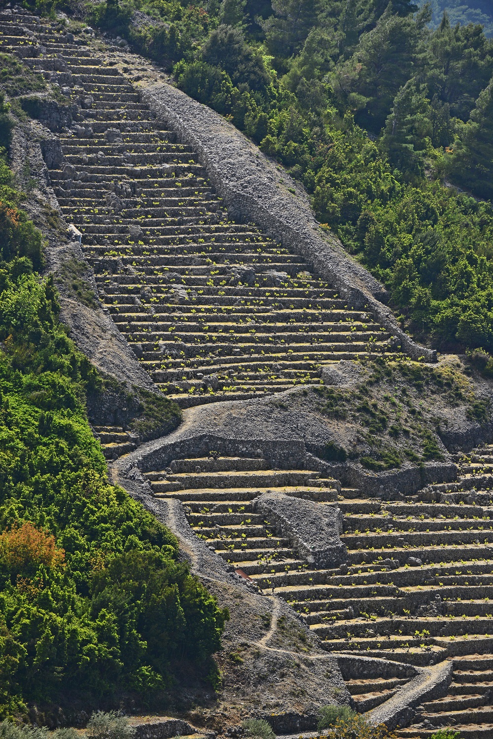
This piece of UNESCO heritage is an art of its own and is an old tradition which continues to be nurtured on numerous islands and in coastal Croatia, but it’s especially interesting on the island of Vis. This type of rural architecture is part of the Vis landscape and has a different form than the rest. The story of dry stone walling is a story about survival, where peasants used their skills in rocky landscapes and securing smaller fertile areas to grow their vineyards and deal with other types of agriculture.
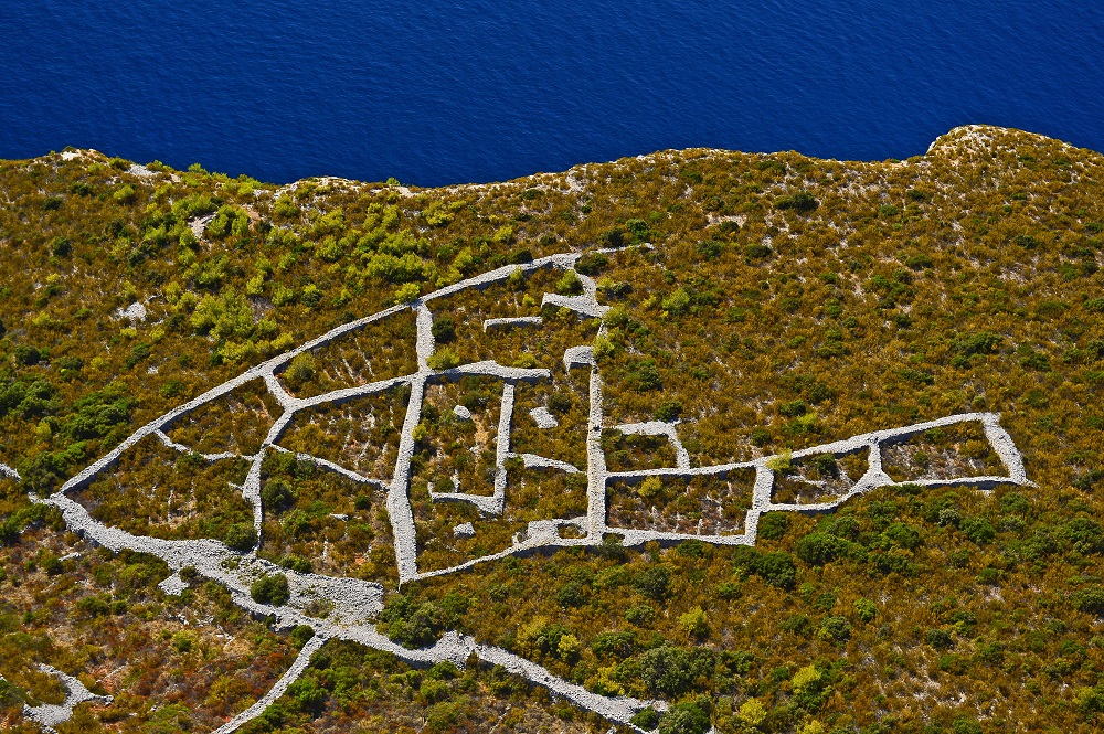
On Vis, the village of Dragodid near Komiža is very well known for its dry stone walling heritage and remains a place for dry stone workshops to this very day.
The Cokavian dialect of Vis
This is another piece of intangible heritage of Croatia and the oldest Slavic dialect in the Eastern Adriatic. It is unique in the fact that it preserves the lexicon from the lingua franca idiom, which is characteristic for the maritime and fishing world. Here is an example of the traditional cokavian dialect of Vis:
U śpȍmen nȍni Juvãni
Śvãku jȕtro
cîn bi źorâ źarudȉla
cîn bi źvȍna źaźvonȉla
ol śnâ bi śe vãrgla
pôk bi źavōpȉla
Ôva Marȉja
śvãki dôn źa pūlnê
kal bi śûnca grûźd śaźrîl
a iź kanpanȅla śe źvûn jōvîl
ol śtolâ bi śe dvȉgla
pôk bi źlãmen
krīźâ ucinȉla
Ôva Marȉja
ondâ jȍpet u śutûn
źajȅcol bi źvûn
a nâ bi pośôl dofinȉla
pôk bi śȅla u kantûn
krȕnicu molȉla
glōvûn obandovãla
kriźȉć buśivãla
i źãrno po źãrno
prȉko pãrśta voltovãla
Ôva Marȉja
i ȍto tãko je nȍna
iś Gūśpûn cavarjãla
trî pūtâ nã don
na plãc źvȍna
molȉtve olpivãla
i da śe nî śvȁ
u molȉtvu pritumbãla
do glũhe źemjê
da nî prĩgla śȉju
śigûr śon
jȍś bi vãvik
naźdrovjãla
Ôvu Marȉju
– Vinko Kalinić (From the collection of songs)
SOURCE(S) (text and photos): UNESCO, Geopark Vis
Find out more about Croatia’s incredible UNESCO heritage by following our dedicated lifestyle page.