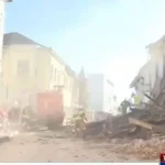
The system is the result of the joint efforts of the Central Office for the Development of Digital Society (SDURDD), the Faculty of Geodesy in Zagreb and the State Geodetic Administration (DGU). The system will collect data on the effects of earthquakes in the field covering almost six thousand hectares, all communities, farmland and commercial structures as well as data regarding residents’ addresses, health institutions and schools.
As Deputy Prime Minister and head of the task force dealing with the aftermath of the earthquake Tomo Medved said, this is a tool that will facilitate the work and decision making by the ministries of the interior and defence, fire services and the Croatian Mountain Rescue Service (HSGSS).
The application will be systematically updated on the size of the population and their social status for instance. This is a useful tool particularly regarding the removal of damage and reconstruction of buildings in earthquake-hit areas seeing that it contains photographs and information on the situation with the ground prior to and after the natural disaster.
The application is available to services participating in the removal of debris and reconstruction.